Sunday 29 May 2016

Revisit Orumana Mission Station, Namibia - 35 years later

So how much did it change?  Or not changed, in 35 years?

I revisited this site on 30 April 2016, 35 years after i have last seen it. Of course it looked different, actually VERY different.  If i did not prepare myself to find the house, and been a bit "over confident" to drive in, talk to the local people, ask permission to go and look, i could not have done this. Even when i found the house i was uncertain, but walking around it i recognised the features and of course, photos don't lie.  Unless it is a photo of yourself! Like on your ID of drivers' license!

The Orumana mission station is now quite populated with many buildings added.  The house we lived in is without residents, the doors are boarded, the windows broken, dirty inside (with faeces on the floor).  See photo below. I wonder why no one lives in it?


I attach a "then and now" pic, the view from the house we lived in.  Except for superficial changes, like fences, vegetation and overhead wires, 'nothing changed'.  Well, this isnt true, but the similarities after 35 years are VERY very obvious. I numbered interesting features in the pics:


  1. the mopani tree is thicker (see the fork to identify the tree)
  2. this little retaining wall is still intact, with NO improvement or deterioration in 35 years!
  3. little outbuilding is still the same, even same colour.
  4. the 'sandstone' walls...still 100% the same.
  5. look at the branch, at the arrow...is this still the same after 35 years?  Looks like it, amazing!
  6. retaining wall, parallel with road, still there.

Friday 20 May 2016

20 May 2016 – Home

20 May 2016 – Back Home

This post is to wrap up the trip.

The trip went well without any negative events. We followed our planned route, with a few exceptions where there were no roads! The route can be done with a 2x4 'bakkie'.  Car may suffer.

The Ford Ranger 2.2 (diesel, double cab, 4x4) gave no troubles at all.  Although word goes around that the standard tyres (Continental CrossContact 255/70 x16) are poor, and prone to punctures, and specially side-wall punctures, we had no punctures at all.  Of the 10 000 km we drove, about 40% were gravel, or not tarred. I post a KMZ file (opens in Google Earth) that can be loaded to show the exact route we drove as on the map below.

https://drive.google.com/open?id=0B1bFxqxkWpJUM1ZyUThOYW1mNTQ
We started at the green on the bottom of the map, followed the green, and moved east and south on the red line.  The blue is the actual route.
All the KMZ files were recorded with GeoTracker (Android app), except the part from Twee Rivieren to Augrabies.


We drove:
  • 10 025 kms
  • used 954 litres of diesel (no water or oil needed)
  • ‘filled up’ 17 times
  • with a fuel consumption of 11.34 km/l over this period
  • i used 500ppm diesel
  • i used 'Fuelio' a free Android app to record the fill-ups


Total cost was about R30 000 (i.e. money spent directly); with accommodation and diesel the main contributors. The clip from Excel shows expenses in the categories captured.  The graph below shows the same data graphically.

Things we took with and not used (i.e. did not need):
  • too much clothes
  • extra spare tyre
  • extra water (25l)
  • tools (spanners, various pliers, wire, extra jack, 'planks' to jack up on (not to depress in sand)
  • kindling
  • medicines
  • spade
  • tripod for camera
  • backpack (20l)
Best choices:
  • A3 Flip-file with a double facing pages for A3 map, and 
  • printouts of payments for bookings (a few places did not know we were fully paid)
  • multi-plug
  • 'Cloth' coolbag (e.g. P'n'P style)
  • 12V fridge
  • snacks in Tupperware 'tray'
  • proof of address
  • change (small denomination money) for tips, curious, etc.

Maps:
We had the MapStudio Namibia Adventure Map (1:1 650 000 digital) 1st edition (bought ± Jan 2016).  We bought it online, and printed it to a scale that fitted our needs per day. There are major mistakes on the map, e.g. roads shown as tar but are two-tracks, and vice versa, and roads that are cul de sac, but shown to connect with other roads, etc. We had various GPS programs we navigated with (mainly used CoPilot and Sygic). These are offline GPS navigation that don't need data, but GPS signal. They served us well. Many B, C and D roads' numbers changed and are not correct on paper and GPS maps.  This however had little impact on our plans as it were upgrades of roads.

I took 1058 photos, totalling 4.74 GB. This number includes a few videos.
I used Flash Renamer to rename photos and used the standard:  <ExifDate>_<ExifTime>_
'desired name'
This will sort your pics in the date/time it was taken ... most useful. Renaming took <10 minutes per day.


Thx to Magriet, Dominique and Tania who looked after the house and dogs, Maretha for her 12V / 220V fridge, Dominique again for four plastic crates. Thx to family we stayed over with in Cape Town (Jean, Carel, Elaine, Hennie and Ria) and for all of you that followed the blog and supported us with Whatsapp and phone calls while on the trip.

Direct any questions to Johan at:  johanbaard@gmail.com

Sunday 15 May 2016

13 - 14 -15 May 2016 – Hondeklipbaai and St Helenabaai.

13 - 14 - 15 May 2016

We travelled from Augrabies Waterfalls to Hondeklipbaai and then on 14 May on to  St Helena Bay and on to Cape Town.


Raining at Augrabies.


We woke up at Augrabies 13 May and had some drizzle overnight.  


We left for Hondeklipbaai. We really chose place names from a map; and thought how much there is that we have not seen. Machu Picchu may be a life ambition, Hondeklipbaai was only a place on a map.  The drive was a very nice one.  We saw places with exotic names like Pofadder.  Pofadder actually is a quite nice little village.  


Last 3 days' trip.
We drove on and there were still clouds overhead and we could see a storm (a small one) brewing.  Then it rained.  We saw signs of this rain for a few hundred kilometers. It is a ‘blessing seeing rain in a 'desert’.


We reached Aggeneys, a mining village started about 1978.  This area is ‘desert’.  The town was well laid out and tended.  The town now is much more than an oasis.  If you think ‘barren landscape’, barren landscape is the area surrounding the town of Aggeneys, if you visit the town, however, it is almost a forest of trees.  Some species were poorly chosen (Silky Oak), but others were excellent choices, e.g. Apiesdoring. The Apiesdoring is standing 15-20 m tall.  This proves that a barren landscape does not mean barren soil.  Add water, and love via maintenance, and you can work wonders.  Well done Black Mountain Mining.
A 'worsboom', Kigelia africana, in Aggeneys.
Apiesdoring, Acacia galpinii. About 40 years old.

We really enjoyed some of the open landscapes, then rocky, the rain on the horizon, the low clouds, the cumulus clouds….sometimes it was quite dramatic.


Lucky to see many Kokerboom in flower.
All the towns looked vibrant; Springbok, Garies, Nuwerus…all clean and working.
Kamieskroon
Garies
Nuwerus
Lutzville
Papendorp
Strandfontein
We drove on to Hondeklipbaai (HKB) (Hondeklip Bay). It was actually named after a stone (rock) that was shaped like a dog.  But the ear was removed and the nose broken off by lightning; it is said.  
Old farmstead on the road to Hondeklipbaai.


We did not realise it, but it was around 80 km in to HKB, and same out, of course, this morning.  The gravel is quite good and the landscapes such that you have much to look at.
Typical farmscape on the road to Hondeklipbaai.
Hondeklipbaai has a fishing harbour, lots of small houses where the local coloured peopled lived and now European businesses, i.e. accommodation, pubs restaurants (I use plural liberally) interspersed.  This is the first true racial integration I saw.  More followed in St Helena and Paternoster and probably most of the former small fishing villages. 


Typical street scene late afternoon

Although Hondeklipbaai (town / village) has little to offer I am glad I visited this quaint village.  We stayed at ‘Hondehokke’.  Except for ‘no electricity’ and no view from where we stayed, I still enjoyed it. It has character, a vibe, and I enjoyed it.
Sunset at HKB.
We left Hondeklipbaai shortly after sunrise and drove in thick fog to the tar road (± 80km).  It was only mildly scary, at 80 km/h, with the fog, but also beautiful landscapes through the mist and sunrise.  We are on our way to St Helena Bay.
We drove to Strandfontein.  On its welcoming sign it says ‘Welcome to the jewel of …”  Strandfontein is nice.  
It has very nice modern houses and is a sprawling town.  

We saw the normal road signs.


We left for Doornbaai.  We followed an excellent road, marked ‘Private’ that runs next to the ‘Sishen – Saldanha’ rail.  Although it had 'all prohibited' signage, we drove it.  What a good decision. It runs straight, it runs along the coast.
When we got to Lamberts Bay, suddenly there was a boom, and security and we were asked for our permits.  I claimed to have got lost and were let through.  

If you ever have to travel north or south, here, follow this road and sort out the security later. Murderers walk free in SA, you won’t go to jail for driving here. There are also many entrances and exits; mostly without security.  I think security was only at Lamberts Bay as it is a large town.  

We passed Dwarskersbos and Velddrif.  All worth seeing and visiting. We arrived at St Helena Bay; we wanted accommodation in Paternoster.  We had little luck in Paternoster and settled on St Helena Bay.  Also a ‘small’ town, but now sprawling over a large area with new developments up the hills, mostly open erven still.  This is where our accommodation is situated.  It is very modern and well equipped. The shower is actually a ‘shower room’.  

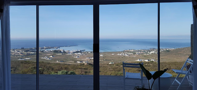
View over St Helena Bay.
A room with a view.
We went to watch the rugby in a local pub.  Always nice to interact with the locals.  The Stormers scared us with their last minute draw against the Sunwolwes.  The town was probably a small fishing village before it was ‘discovered’.  The beach is sandy with round granite sticking out from the sea, much like the Clifton - Llandudno area. The properties next to the sea are either factories, old and often dilapidated) and the original small ‘coloured’ houses.  Today they are very fortunate to have these properties. 

The sun rose straight from the sea granting us a beautiful sunrise on the last day of our Namibia Trip.


Next few days we are visiting family and friends before arriving home on Thursday.  I'll post some statistics then, e.g., kms travelled, money spent, fuel economy, maps of route and, if possible, a downloadable kml (Google Earth) file.

Thursday 12 May 2016

11-12 May 2016 - Twee Rivieren and Augrabies

11-12 May 2016 - Twee Rivieren and trip to Augrabies, and time at Augrabies Waterfall

We had a short drive today; about 370 kms.  We could only leave Twee Rivieren camp (to go through customs) at 7.30 am. The passports were all stamped last night and except for the 'entry gate permit' that had to be stamped, all the paper work was done. Going through customs was no more than a 'wave through'. No inspections at all.  It is always worrying what nonsense an official can get up to.
We saw the usual signs, but sheep appeared.  We never saw signs warning about domestic goats and donkeys.  These were most abundant in Namibia.

These rules were stuck up on a notice board.


Our accommodation in Twee Rivieren was good and spacious. Two units are adjacent so you have neighbours.  It is mostly pleasant to have a chat with all these old folk ;-)).  Our neighbours are from Plett and they have three weeks in Kgalagadi.  Three weeks? That is a LOT of time to

 be in Kgalagadi.  They are also mostly camping and had three days of rain, camping, before they reached Kgalagadi.


We saw all kinds of animals.  Leopard, lion, hyena, giraffe, various antelope, owl, etc, etc.  We loved the ground squirrels. No elephant or buffalo, no crocodiles (no water actually).


This guy came out at dawn, got a good spot, and looked out for tourists all day long.  It was very excited to see a CX vehicle.


The landscapes are more exciting to me than the animals.  Animals complement the landscapes. And i love roads in pics.


The scenery was particularly beautiful from the exit of Twee Rivieren, to the T-junction to Upington (R360).  This were camelthorn and red dunes; the way i think of Kalahari.  We saw some bushmen trying to 'do craft trade', but it was really 'low budget' stuff.

The roads in Kgalagadi were the poorest unsurfaced roads we encountered on a 10 000 km journey.  They were quite corrugated, but saying that, they were not THAT bad. We deflated to 1.5, but i think lower could also work.  We never encountered any place where we thought we may get stuck, i.e., that is we did not need 4x4! Although i used it when i felt it could be safer, e.g. 'high speed' driving, to get better traction on gravel. Maybe we took the 'wimp roads'.

We arrived at 1.30 pm here in Augrabies, was well received and the accommodation is 'perfect'.  The scenery is beautiful.  We had some large raindrops throughout the day, but not ral rain.  The clouds added to some pics, and spoiled others.  The water over the falls are not much.  We were impressed by the quality of the 'board walks'.


General landscapes at falls.

 Viewing deck at falls.

 General landscape.
 General landscape.
 Main falls.

 Main falls.


 View over areas.

Canyon, below falls.

Tomorrow we drive to Hondeklipbaai.  We don't expect much so we may be surprised. We'll see the sea!

Internet connection: As we don't get wi-fi, we use our phone's "mobile hotspot and tethering" function.  Although internet connection is slow, this often pulls us through and make blogging possible, although frustratingly slow.